


Why do we need geobotanical sites?
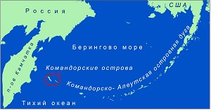
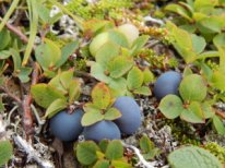
The specialists of the Commander Islands Nature and Biosphere Reserve conduct all scientific activities in the framework of Ecological Monitoring Program. It has 8 divisions and 81 themes. All these groups of activities have their due periodicity: permanent, every year or periodical from once in two years to once in 15 years! In the Commander Islands Reserve the Program covers a large scope of themes: from landscape monitoring to anthropogenic pollution, from cetaceans research to analysis of mouse-like rodents. One of the permanent and every year activity is flora monitoring. Within the Program the botanist of the Commander Islands Reserve Angelica Shilova does phenological observations, notes the periods of start and end of vegetation and fruiting; counts the harvest of berry shrubs; estimates the population state of rare plants; searches for new spots and new species of rare plants; describes the local flora and estimates the state of edible plants. One of the important activities to evaluate the state of plants in the reserve is to determine the model plant types and to monitor some of the spots for many years.
That is why geobotanical sites are chosen in some of the plant communities. In fact it is a rectangular site 10X10 meters. On any territory under research we choose permanent sites to cover the maximum of model plant types and choose separate sites for rare or disappearing plants and berry shrubs of different types. For example, the Commander Islands Reserve has a site to analyze Russian Red Data Book species, such as a permanent sample area to monitor Cypripedium macranthos near Nikolskoye village or Cypripedium yatabeanum monitoring sites in the Starogavanskaya river valley or near Severnoye rookery.
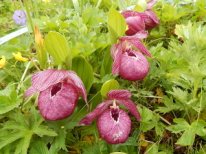
. 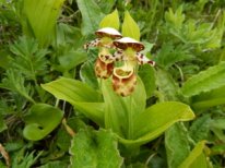
Every year here during blooming season the specialists count the number of generative and vegetative shoots and evaluate the condition of the population. On other permanent sample sites every year we record the present species and evaluate the model plant type state, as well as we conduct phenological observations and counts, such as berry harvest counts. Every sample area has its number, which is included in the data base and rests the same throughout the whole period of monitoring.
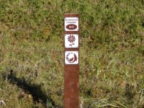
Without doubt we have GPS coordinates of all the sites, but to find it easier of the spot we have a tradition of marking the permanent sample areas. In forest ecosystems it is usually an easy task, as tree trunks can be used as corner points. In tundra it is more difficult and very important. This summer we started the work on botanical sites marking: the corner points are now highlighted by wood posts, one of the corners has an informational plate with the number of the botanical site on it.
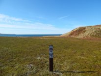
Today on the Commander Islands 39 permanent sample site were made, 3 of which are on Toporkov Island and 36 on Bering Island. They are all situated in different part of the islands and cover different plant types. We plan to make permanent sample areas on Medny Island as well in the nearest future. The marking of such sites on the territory is critical for plant monitoring during long period of time, as the procedure must be made on the very same site as last year. In case of using GPS navigators to find the site, we have a high risk of deviation, which can reach meters. Such errors lead to incorrect results and the loss of a long biological sequence. That is why it is crucial to save the posts and plates for many years to come.