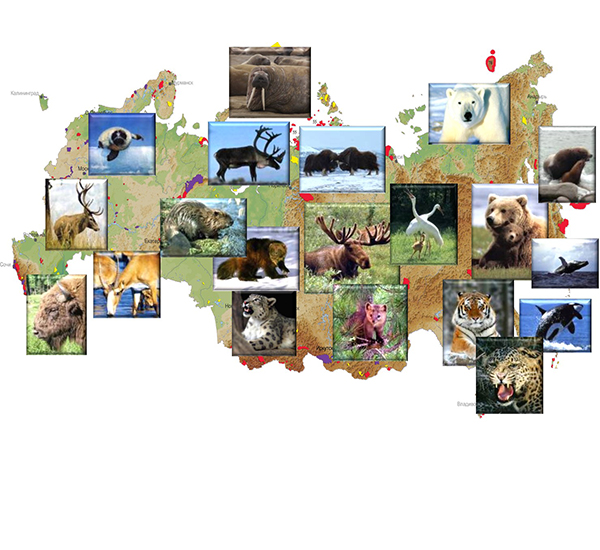

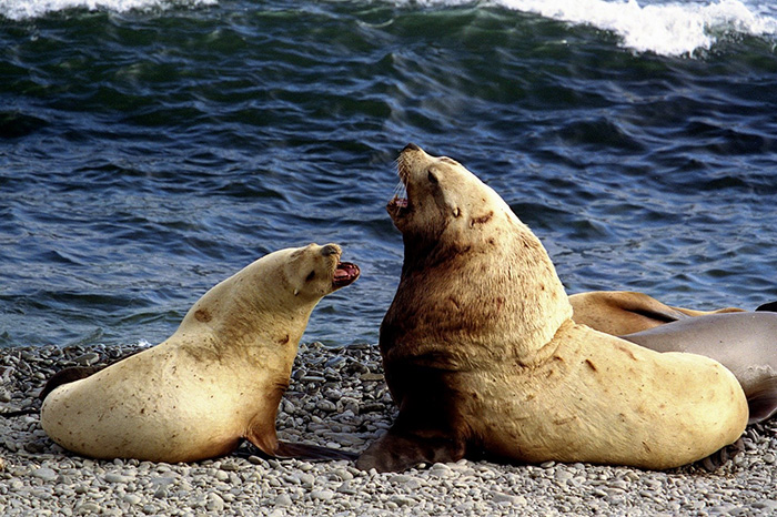


Territory
Littoral Zone & Ocean Activity
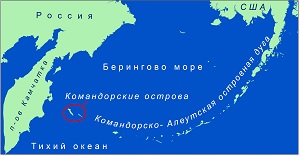
Geographical position
The Commander Islands Nature and Biosphere Reserve includes the Commander Islands and a 30-mile sea area of 3 648 679 ha.

Geographical Position of The Commander Islands Nature and Biosphere Reserve
Geographical position, geological history, peculiarities of structure, climate and hydrological conditions of the surrounding water area, these are the defining features of the unique flora and fauna of the reserve.
The Commander Islands are located in the northwestern part of the Pacific Ocean (the Pacific Ocean is the oldest ocean on Earth, which appeared during the Paleozoic). They have the Bering Sea in the north and the Pacific Ocean in the south.
The Commander archipelago is the western part of the Aleutian Chain, which is also called the Commander-Aleutian Arc because of its peculiar geological history and location. The Commander Islands are separated from the main part of the Aleutian Islands by a wide strait. The Commander-Aleutian Arc includes 150 islands and 47 straits. Its total length is estimated at 2260 km (this is the longest island chain on the planet). It connects two continents – Eurasia and North America – like a bridge.
The Commander Islands are located at 55° 25’ and 54° 31’ N. and 165° 04’ and 168° E.
The islands are separated from the Kamchatka Peninsula by Kamchatka Strait which is almost 190 km wide and 4420 m deep (it is the deepest and the largest (in cross-section) strait of the whole island chain), and from the rest of the Aleutian Island Arc – by Blizhniy Strait which is a little more than 363 km wide and 2000 meter deep. Bering Island and Medny Island are separated by Admiral Kuznetsov Strait with width of 49 km and depth up to 146 m.
The Commander Islands include 2 large islands– Bering Island and Medny Island and 2 small ones – Arij Kamen' and Toporkov Island.
On the side of the Pacific Ocean the islands have theAleutian Trench, which is 7000 meter deep. The steepness of the underwater slopes is 30-35 degrees. Despite the fact that islands mainly have a rather wide insular shelf, at some points the slope is only 4-5 km wide (near the Poludennaya Cove on Bering Island).
Bering Island is the largest one on the Commander archipelago, its total area reaches to 1667 km2 (166 700 ha). The length of the island from the North to the South (from the North Cape to the Cape Monati) is about 90 km. The maximum width of the island is 35 km (from the Northwest Cape to the Vakselya Cape in the north of the island), and minimum width is 2.4 km (from Elina Cove to Likandrovskaya Cove in the south). The coastline is 257.4 km long.
The highest point, Mount Steller, stands at 755 meters, and on average Bering Island is 150-755 meters above sea level.
The island got its name in honor of the captain-commander Vitus Bering.

The northern part of Bering Island is low and flat. Photo by Dmitry Pilipenko

The southern part of Bering Island is mountainous. Photo by Eugene Mamaev
Medny Island is the second largest island of the archipelago. Its total area reaches 186 km2 (18 600 ha). The length of the island is 57 km, at its widest point it is 8.4 km wide (from the Cape Zhirovoy to the CapeSenkinskiy), and at its narrowest one – 0.35 km (from Sekachinskaya Cove to Peresheek Ostrovnoy Cove). Medny Island is slightly lower thanBering Island – 360-647 meters; the highest point is Steyneger's mountain (647 meters). The coastline of Medny Island reaches 164.9km.

Medny Island is covered with mountains. Photo by Eugene Mamaev

It is hardly possible to find at least one horizontal surface on Medny Island. Photo by Eugene Mamaev
, which was discovered almost together with the island in the 18th century. Photo by Alexey Chetvergov")
Medny Island got its name because of its copper (‘copper’ in Russian sounds like ‘med’’), which was discovered almost together with the island in the 18th century. Photo by Alexey Chetvergov
Toporkov Island is located to the North-West of Bering Island in Cove Nikolskiy Raid. The island is flat and reaches a height of 9 meters. Its total area is 0.25 km2 with perimeter about 2 km.

Toporkov Island is actually a flat plateau. Photo by Eugene Mamaev
Toporkov Island got its name because of the colonies of tufted puffins (“toporky” in Russian), which are numerous here.
Arij Kamen' Island is also located to the North-West of Bering Island. It is a rock towering up to 53 meters above sea level. The total area of the island is 0.08 km2 with the perimeter of about 1 km.

Arij Kamen' Island is a rock towering up to 53 meters above sea level. Photo by Eugene Mamaev
Arij Kamen' Island is called so because of the numerous guillemots which are nesting here. In Aleut they are called ‘ara’.
There are up to 60 separate buttes (or sea stacks) and surface stones beside the coasts of the islands. Sobachiy (‘dog’) Post, Bobrovye (‘beaver’) Stones and Steller’s Arch are the most notable of them.

Along the coasts of the Commander Islands there are dozens of sea stacks. Photo by Eugene Mamaev.

Steller’s Arc is the most famous butte which is situated on the west coast of Bering Island. Photo by Dmitry Pilipenko
Origin of the Islands
The Commander islands, as well as the entire Aleutian Island Arc, are the tops of the underwater volcanic ridge. Rare-earth elements found in the Commander’s lavas prove that the islands are oceanic by origin and lie on the seabed, though in a number of works they are considered to be of a transitional type.
The Commander Islands appeared as a result of the early phases of Cenozoic volcanism. Experts distinguish 3 stages of volcanism. For a long time it was thought that there was no 4th, modern stage of volcanism, typical of the Aleutian Arc, on the Commander Islands. However, in 1984 the Vulkanologov Massif with active underwater Volcano Piypa was found in the Commander structural basin 70 km north-east of Bering Island.
During the 1st stage (50-40 mln years ago) volcanism was active in the deep-sea level. It was the time when the foundations of the islands were formed. Now the results of this stage can be seen from Poludennaya Cove on the west coast of Bering Island and Commander Cove on the east coast up to its most southern point - the Cape Monati. Influence of this stage can be found on Medny Island as well from the north extremity of the island to Korabelnaya Cove on the east coast.

The Cape Monati is the southernmost extremity of Bering Island. The traces of the 1st stage of islands volcanism can be found here. Photo by Eugene Mamaev

Bobrovye Stones is the most northern extremity of Medny Island. The traces of the 1st stage of volcanism can be found on this island. Photograph by Eugene Mamaev
The 2nd stage of volcanism was 20-15 mln years ago. It formed almost the entire northern part of Bering Island and a small segment of Medny Island – from Korabelnaya Cove up to the Black Cape. This stage of volcanism took place already in shoal water.

The northern part of Bering Island was formed during the 2nd stage of volcanism on the islands. Photo by Eugene Mamaev

The Black Cape on Medny Island was formed during the 2nd stage of volcanism. Photo by Eugene Mamaev
During the final 3rd stage (5-2 mln years ago) the structures of the North-West Cape on Bering Island and the entire southern part of Medny Island were formed, starting from Glinka Cove. This stage took place above sea level.

The North-West Cape on Bering Island was formed during the 3rd, final stage of volcanism on the islands. Photo by Eugene Mamaev

The South Cape of Medny Island. The southern part of Medny Island was formed during the 3rd, final stage of volcanism. Photo by Eugene Mamaev
The common elevation of the islands took place at the end of the Paleogene, the beginning of the Neogene (23 mln years ago). Buyanovskaya rock was formed.
Then a new immersion and a formation of Kamenskaya rock followed; the modern folding of the islands is formed. This period in the evolution of the islands goes back to the end of the Miocene (5 mln years ago). The next step was elevation, which raised the total area of the Commander Islands above sea level.
At the end of the Tertiary period (2.5 mln years ago) the final volcanic outbreak happened. It made the total area of the islands rise above sea level (approximately between 200 and 70 thousand years ago).
Apart from volcanism, tectonic processes of plate motion also contributed to the formation of the islands. These processes took place in the Quaternary period (less than 2 mln years ago). Unified blocks of the islands were split and displaced. The largest shifts are seen on Medny Island in the Cape Zhirovaya, Gladkovskaya and Korabelnaya, near the Isthmus. One of these shifts can be found in the Cape Korabelnaya – the southern part of Medny Island. It is shifted to the North-East of its northern part, the island looks broken.
On Bering Island the places of shifts are also clearly seen. For example, the valleys of the Gladkovskaya River and the Polovina River. Another group of shifts is depicted in the valleys of such rivers as the Kamenka River, the Starogavanskaya River and the Tovarisheskaya Shayba River – the set of currents sharply changes from north-west to latitudinal. These rivers flow through strongly curved valleys. A number of shifts gave the islands their modern look of the coastline.
In the Quaternary period there were new elevations, which can be traced by sea terraces, especially in the northern part of Bering Island. Thus, the 200-meter high terraces were formed in the mid-quaternary period (about 800 thousand years ago), and 20-meter high ones – in the upper-quaternary period (about 100 thousand years ago).

The coastal terraces were formed at different time depending on the tectonic activity of the islands. Photo by Eugene Mamaev
Quaternary glaciation (2-1 mln years ago) contributed a lot to the formation of the Commander Islands. On Medny Island and in the southern part of Bering Island you can find glacial troughs with cirques on top.

The glacial trough on Medny Island is the evidence of Quaternary glaciation on the Commander Islands. Photograph by Eugene Mamaev
Nowadays the islands are still lifting. The lifting rate is about 2.2 mm per year.
Since the islands are located on the border between the Bering Sea plate and the Pacific plate significant geodynamic processes take place here. Because of this interaction, the islands shift towards the Kamchatka Peninsula at a rate of about 50 mm per year (according to the preliminary results of the research).
Climate & Weather
Throughout the history the climate on the Commander Islands has changed from subtropical to boreal. Quaternary glaciation has its traces here (2-1 mln years ago).
Climate and weather conditions in the North Pacific are determined to a great extent by the atmospheric circulation which is represented by a system of areas of low and high pressure. The Low Pressure Centre (cyclonic) is located to the north of the Aleutian Island Arc in the area of 180° E and is called the Aleutian depression or the Aleutian minimum. This is an area of the lowest pressure. The South Centre of theanticyclonic system of high pressure is called the Honolulu maximum of pressure and is located near Hawaii. The atmospheric pressure is not stable in the Aleutian depression over a year – the minimum is observed in December-February, and the maximum - in June-August. During the warm season the Aleutian minimum and the Honolulu maximum have the main influence on the weather near the Commander Islands, and during the cold season the Aleutian minimum interacts with the developing in this period Asian anticyclone. This interaction defines the weather during the cold season.

The centers of atmospheric action, which define the Commander Islands climate
The climate and weather on the Commander Islands depend largely on the cyclonic whirlwinds, which appear between the atmospheric action centers. The islands are located in the transition zone the majority of cyclones. When the center of the Aleutian minimum is set near the Commander Islands, warm air penetrates the Bering Sea and winter is mild.

The Commander Islands are situated on the way of the most cyclones heading to the Bering Sea
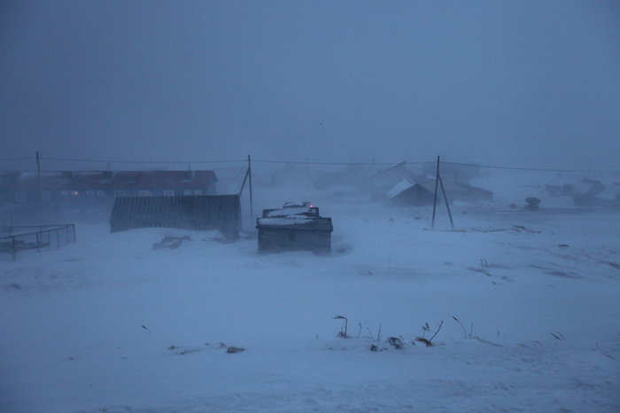
From November till March the Bering Sea basin absorbs from 7 up to 14 cyclones, arising in the south of the Asian continent. During the year the Bering Sea deals with 50-60 cyclones. According to the long-term data there are two areas with the highest frequency of cyclonic periods in the North Pacific – The Gulf of Alaska and the Commander Islands. Due to the fact that cyclones in the Bering Sea turn into extensive sedentary depressions (the areas of low atmospheric pressure), absorbing new cyclones, the duration of continuous cyclonic activity may last up to 14 days. This causes frequent long storms, snowfalls and blizzards.

Frequent and prolonged cyclones cause severe storms. Photo by Eugene Mamaev
Apart from atmospheric circulations,the cold Kamchatka Current and branches of the warm Kuroshio Current have a great impact on the climate of the islands.
Because of the peculiarities of the geographic location, climate on the Commander Islands is maritime, mild and humid. The diverse weather with prolonged precipitation, gales, cloudy weather and smooth seasonal precipitation and temperature fluctuations is typical of the islands.

Winters on the Commander Islands are mild and a narrow strip of thin ice forms only near the shore. Photo by Nadezhda Ryabchunova
Seasonal changes are mild as well. Spring begins in the middle of April and lasts until the end of July. The level of precipitation during this period is low. In June the amount of days with low clouds and fog increases, therefore warm days are rather rare.
The concept of summer on the islands is conditional. During the summer months weather with low clouds and drizzling fog prevails, the air doesn’t get warmed thoroughly, only during some exceptional years the average daily air temperature exceeds 15 degrees. During this time there is more precipitation than in spring. The average wind speed in comparison to the other seasons is the smallest – about 5 meters per second.
In fall, after the increase of cyclones frequency, the amount of precipitation and the wind speed also grow. The probability of gale-force wind increases.
Air temperature. The average annual temperature on Bering Island is positive and is 2-2.5°C (35.6 -36.5° F); on Medny Island it is 2.8° C (37.04° F). The coldest month is February (-3.7° C or 25.34° F), the warmest one is August (+10.6° C or 51.08 ° F). The absolute minimum on the islands was -23.5° C (-10.3° F) registered in February, 1903, and the absolute maximum + 21.5° C (70.7° F) in June, 1938. Thaws in cold season and cold snaps in warm season are very common. The steady freezing period comes in the first decade of December and lasts until the beginning of April. The total duration of the freezing period is 125 days.
The combination of low temperatures, high relative humidity with considerable wind speed makes the climate of the islands extremely uncomfortable and severe.
Frequent winds and high humidity make the living conditions on the Commander Islands uncomfortable. Photo by Anastasia Kuznetsova
Air humidity. The islands are characterized by very high relative air humidity throughout the year. A bench mark of «dryness» is humidity of 30% and less. According to this mark there are no dry days on the Commander Islands. Humidity reaches its maximum in the summer period – 91-93% when cloudy weather with fog and drizzle is frequent.
Atmospheric precipitation. The average amount of precipitation on Bering Island is 660-690 mm per year and up to 1213 mm on Medny Island. This is much less than, for example, on the Kamchatka Peninsula. The number of days with precipitation on the Commander Islands is 270-280 days per year. The average duration of rainfall on days with precipitation is 8-9 hours. Maximum precipitation falls to October - November. One of the peculiarities of the islands is a small intensity of precipitation. There are frequent drizzling rains. Thunderstorms are rare on the islands, but the autumn months gladden the eye with unexpected rainbows.

Rainbows on the islands are frequent in autumn. Photo by Eugene Mamaev
Wind. The Commander Islands are characterized by a complex wind regime, which is directly related to the general circulation of the atmosphere in the Asia-Pacific region. In the cold period winds of the northern and north-eastern points of the compass prevail, in summer it’s usually the south-western and western winds.
The average annual wind speed on the islands is 6.8 meters per second (24.5 km/h), herewith during the year there are at least 1-2 days, when the wind speed becomes a natural hazard of 33 meters per second and more (119 km/h and more). The registered maximum on Bering Island is to 50 meters per second (180 km/h).

Due to the strong winds storms are formed. Their frequency increases significantly in autumn. Photograph by Eugene Mamaev
The strongest winds are characteristic of the autumn-winter period and the gentlest of the summer period. According to long-term observations, the average number of days with wind more than 15 meters per second (54 km/h) within a month in winter is 15-18 days, the maximum is 28 days. Herewith, the average annual number of days with wind speed more than 15 meters per second is 80.

Sometimes protracted autumn storms lead to disastrous consequences. Photo by Eugene Mamaev
Medny Island and the southern part of Bering Island are places where special local winds are formed because of the peculiar structure of the surface (severe mountain orogeny). Breaking through the narrow valleys the wind rolls with great force down the leeward slopes.
Snow cover. The first snow cover on the islands is formed at the beginning of November though the time limits can be shifted to 2-4 weeks. The earliest snow was observed on October, 23. The first snow usually melts. The steady snow cover is formed on December, 1 (according to the long-term average annual data). Melting begins in April, and the final coming off in early May. However in glens snow may lay throughout the summer and some years has even no time to melt.

Blizzards are frequent on the Commander Islands in winter. Photo by Eugene Mamaev
The number of days with steady snow cover is 160.
The snow cover reaches its maximum height at the end of March – 80-100 cm. Low height of the snow cover is related to its high density and blowing process. Frequent winter thaws are greatly conducive to this.

After protracted blizzards deep snowdrifts are formed. Photo by Alexander Afanasyev
Fogs. The Commander Islands are known for their fogs. During the year, the average number of foggy days is 55, and in some years - 98. The most foggy month is July (up to 17 days per month, the maximum is 29 days).

Fogs are frequent on the Commander Islands. Photo by Artem Komarov
So-called advective fogs are formed here most frequently; they occur when warmer air meets colder water. This happens because of moderate winds constantly blowing in one direction of south points of the compass. The reason for the frequent fogs, which come to the islands from the ocean, is upwelling. Because of the upwelling process the cold deep waters rise to the surface, it leads to water vapor condensation from warm air.

Fogs are the symbol of the Commander Islands. Photo by Eugene Mamaev
Blizzards. The average number of days with blizzards is 42, the maximum is 82. Most commonly blizzards are registered in January-March– up to 24 days (March) per month.
Cloudiness. The grey sky is a typical climate peculiarity of the Commander Island. Thus, the average cloud density is 8.3 (that is, every day more than 80% of the sky is covered with clouds). The number of cloudy days per year is 147, which is the maximum for Kamchatka region. The sunniest months are April, May, September and October.

Grey sky is a usual phenomenon on the Commander Islands. Photo by Eugene Mamaev
Soils
Soil-forming rocks on the Commander Islands are andesite-basalts, argillites and sands of the sea. Several types of soil were formed on them.
Tundra podbours are mostly represented in the northern part of Bering Island on the slopes of the hills in Cove Gladkovskaya on Medny Island. This soil is located under papulous tundra.
Underdeveloped rocky surface tundra podbours are less common and occupy apical and ridge-top mountain surfaces; they are located beneath rubbly tundra.
Soddy subarctic seaside soils were formed on the marine terraces, the height of which were 2-5 meters; stacked by sands under rich in herbs and gramineous communities. These are the most fertile soils on the Commander Islands.
Peat and peat-bog soils arelocated on the fens. They are widely spread in the northern lowlands of Bering Island and in the middle and low floodplains.
Dune Fields
One of the Commander Islands landscape characteristics are dune fields. All in all there are 8 large dune fields on the islands. These dune fields can be found on the North-West Cape, in Whale Cove and Cove Nikolskiy Raid, between the rivers the Kamenka and Peshanka, in Peresheek Cove, Lisinskaya Cove, Serebryannikova Cove and Bobrovaya Cove on the west coast of Bering Island, and also in Polovina Cove, Commander Cove and some others on the east coast. On Medny island dunes can be found in Peschschanaya Cove and Korabelnaya Cove on the east coast.
The biggest dune field is located in Cove Nikolskiy Raid on Bering Island and stretches from the mouth of the Gavanskaya River to Whale Cove. Its total length is 7 km, and width up to 800 meters.
The formation of dunes occurs due to the regression periods (lowering of sea level), in which the sand from the dried parts of the bottom was spread by winds. In this way three relatively well marked lines of dunes were formed, having different height and age. Mostly, the first line of dunes with height of up to 2.5 meters, the nearest to the sea, is under 1400 years old. The second line of dunes, whose height is up to 12 meters, is under 3700 years old. The third line of dunes, which is located in the rear part, with height of up to 30 meters, is under 9700 years old. These high ancient dunes are well developed in Cove Nikolskiy Raid, in the interfluve of the Kamenka River and the Peschschanka River and in Bobrovaya Cove.

The dune fieldin the interfluve of the Kamenka River and the Peschschanka River on Bering Island. Photo by Eugene Mamaev
The dunes are generally well-matted and lush. The dune fields in Cove Nikolskiy Raid are an exception; there under the influence of cattle grazing in the 60s of the last century they are in the process of dispersion.
Inland Waters
Inland waters on the Commander Islands are represented by rivers and streams, exorheic and endorheic lakes, peat lakes, swamps, etc. There are absolutely no inland waters on Arij Kamen' Island and Toporkov Island.
Rivers and streams. Bering Island and Medny Island have a dense fluvial net. The rivers are snow-fed and mixed-fed. Rivers are usually not large. The width of the channels is 1-2 meters; in the river mouth area it reaches 8 meters. The depth is up to 1.5 meter. In the southern mountainous part of Bering Island and on the most part of Medny Island river valleys are “suspended”, that means they end up with the cliffs, from which the rivers fall like waterfalls. The heights of waterfalls are between 10 and 200 meters. The rivers of the northern part of Bering Island are flat. These are the Ladyginskaya River and the Gavanskaya River.

In the southern part of Bering Island and in the most places of Medny Island rivers have “suspended”valleys which end up with the cliffs. Photo by Eugene Mamaev
The longest river is the Kamenka River on Bering Island. Its length is 27 km.

The Kamenka River Valley on Bering Island. It is the longest river on the Commander Islands. Photo by Dmitry Pilipenko
Lakes. There are 120 lakes on the Commander Islands with a total area of about 40 km2.
The biggest lake on the islands is Lake Sarannoe. Its area is 31.6 km2. The depth of the lake is 36 meters. Today the level of the lake is 12 meters above sea level. During the Riss-Wurm transgression (the rise of water level) of the ocean 130 thousand years ago this lake was a sea lagoon. As proof of those distant events, the relic crustaceans can be found in it so far. About 20 thousand years ago there was a fall of ocean level, which led to thedesalination of the lagoon and formation of modern image of Lake Sarannoe.

Lake Sarannoe is the biggest lake on the Commander Islands. Photo by Eugene Mamaev
Lake Gavanskoye is the second largest lake with water surface of 4.74 km2. Due to the tidal influence the water in the lake is brackish. The lake is located in the valley, which was a shallow water gulf during the Riss-Wurm transgression. After the low tide of the ocean the lake was formed. As evidence of its "sea" past seashells can be found at the waterhead of the river bearing the same name.

Lake Gavanskoye is located in the valley, which used to be a sea gulf. Photo by Ivan Rybakov
The largest salt lake of the lagoonal type on Bering Island is Lake Peresheykovskoe, which is located in the south of the island near the west coast. The area of its water surface is 0.45 km2. With the help of the channel it connects with the ocean.

Lake Peresheykovskoe is lagoonal by character and its water is salty. Photo by Anastasia Kuznetsova
Another major lake of the lagoonal type is Lake Gladkovskoe on Medny Island.
The most ancient lakes on the Commander Islands are small relict lakes on the Svinye Mountains. They were formed in the Middle Pleistocene about 0.8-0.13 mln years ago.


The relict lakes on the Svinye Mountains are considered the most ancient on the Commander Islands their age is 130-800 thousand years. Photo by Dmitry Pilipenko
Swamps. Due to the characteristic climate and the special conditions of humidification on the Commander Islands swamps have been developed. However, because of the mountain terrain the area occupied by swamps is not that big, no more than 3% of the total area of the islands.
The largest North swamp is located on the 60-meter sea terrace on the northern extremity of Bering Island. It has an area of 8.5 km2. The thickness of peat deposits is up to 2 meters. It has a number of thermokarst depressions which are filled with water. According to the specialists' research the formation of the swamp began about 9.3-5.7 thousand years ago.
The valley of the Ladyginskaya River is a rather large bog array. It has an area of 5.2 km2.
Another major swamp system on Bering Island is the valley of the Gavanskaya River. The total area of this system is about 12 km2. The age of its bog array is estimated at 3-6 thousand years.
Backbogs are located in the downstream of the Polovina River and the Poludennaya River and in the middle reach of the Podutesnaya River on Bering Island, in Peschschanaya Cove, Korabelnaya Cove and Topolevskaya Cove on Medny Island.
Tsunami
The Commander Islands are located in a tsunami-dangerous area. The width of tsunami area along the eastern coast of Kamchatka is from 100 toо 400 km. On the average, one catastrophic and 10-15 «ordinary» tsunamis happen every century. The height of the waves can be from 10 up to 40 meters.
On the Commander Islands there are 2 well documented cases of tsunami – in 1960 and in 1969. The maximum height of water lifting was 1.5-2.5 meters. Kamchatka tsunami of 1952 and Alaskan tsunami of 1964 also had several consequences on the islands.
Sea Currents
Sea currents have a great influence on the climate and biological appearance of this or that part of the World Ocean. The Commander Islands are influences by several basic currents.

The scheme of sea currents in the North Pacific
The warm Kuroshio Current at the Japan Islands level passes into the North Pacific Current, which goes further in the north-east direction to the coast of Alaska. Here it splits into two branches, one of which forms the Alaskan cycle and Alaskan jet stream. The Alaskan jet stream is the main one, which brings the waters of the Pacific Ocean to the Bering Sea through the numerous straits of the Commander-Aleutian Arc. This current comes to Blizhniy Strait, which separates the Near Islands and the Commanders Islands. Then it goes round the Commander Islands in the Bering Sea water area and turns to the northwest, filling up the waters of the Kamchatka Current. A part of the water flow of the Alaskan jet stream goes round the Commander Islands in the south, and is also involved in the formation of the Western Subarctic Cycle. Thus, the Alaskan jet stream brings the warm waters of the Pacific Ocean to the Bering Sea and, washing the Commander Islands, prevents the ice formation around them in winter. In different years the power of the flow and the direction of its individual branches can change, which influences the weather conditions on the islands and the characteristics of the marine ecosystem of the adjoining water area.
From the west through Kamchatka Strait and from the north the cold waters of the Bering Sea are brought to the ocean by the Kamchatka Current. In different years its main flow can go either near the coast of the Kamchatka Peninsula or near the Commander Islands. The speed of this flow is 11-20 centimeter per second.
A branch of the Alaskan jet stream, entering the Bering Sea through Blizhniy Strait and partially through Admiral Kuznetsov Strait, has a speed of 5 centimeter per second at a depth of 0 to 10 meters. The west coast of the Commander Islands is washed to the south by the waterscoming out of a cyclonic circulation over the Commander Basin through Kamchatka Strait. The speed of this flow at the surface is 10 centimeter per second and at the depth 200 meters – 20-40 centimeter per second.
Aside from the surface currents in the water area of the Commander Islands there is also a vertical circulation of water – upwelling. The whole Commander-Aleutian chain is an area of strongly marked upwelling. The upwelling phenomenon is the rise of depth water to the surface of the ocean. The depth water bring biogenic substances to the surface and serve active development of phytoplankton leading to the food chains increase the biological productivity of the ocean (in particular, in areas with a strongly marked upwelling high densities of squids, fish, seabirds and marine mammals are formed).

The bottom configuration of the Commander islands and the upwelling scheme
The upwelling near the Commander Islands is coastal and is associated with topography.
Strong, frequent and continuous winds blowing along the coast cause the rise of depth waters. The submarine relief of the islands causes the same effect – currents which wash the islands hitting up against the steep underwater slopes rise up.
Tidal Ocean Activity
The Commander Islands are located in the zone of the action of fluxes and refluxes of the ocean.
Fluxes and refluxes – are periodic fluctuations of the water level in the ocean due to the gravitational attraction of the Moon and the Sun. The highest water level is called high water (or tide) and the lowest – low water (tide as well). Depending on the position of the Moon and the Sun towards the Earth fluxes and refluxes are distinguished.
In the Commander Islands latitude irregular single day thermals prevail.

During the refluxes extensive reef plates become visible. Photo by Eugene Mamaev
The maximum tidal rate on the Commander Islands is 2.3 meters, and the minimum water level is at 0.3 meters. In the spring and summer months the maximum refluxes occur in the morning and in the afternoon, whereas in autumn and winter - at night. Every day the time of the maximum reflux changes by an hour, and its height is changed to 10-20 cm.